


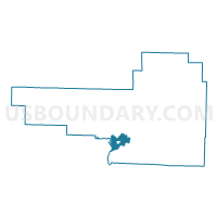
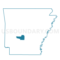
Lower Prairie Voting District, Hot Spring County, Arkansas
About
Outline

Summary
| Unique Area Identifier | 526630 |
| Name | Lower Prairie Voting District |
| County | Hot Spring County |
| State | Arkansas |
| Area (square miles) | 7.76 |
| Land Area (square miles) | 7.65 |
| Water Area (square miles) | 0.11 |
| % of Land Area | 98.63 |
| % of Water Area | 1.37 |
| Latitude of the Internal Point | 34.24202030 |
| Longtitude of the Internal Point | -92.97906680 |
Maps

Graphs
Select a template below for downloading or customizing gragh for Lower Prairie Voting District, Hot Spring County, Arkansas


Neighbors
Neighoring Voting District (by Name) Neighboring Voting District on the Map
- Brown Springs Voting District, Hot Spring County, AR
- Caddo Valley Outside Voting District, Clark County, AR
- Caddo Valley Ward 1, Clark County, AR
- Friendship City Voting District, Hot Spring County, AR
- Montgomery Voting District, Hot Spring County, AR
- Ouachita Voting District, Hot Spring County, AR
- Upper Prairie Voting District, Hot Spring County, AR
Top 10 Neighboring County Subdivision (by Population) Neighboring County Subdivision on the Map
- Caddo township, Clark County, AR (22,995)
- Montgomery township, Hot Spring County, AR (1,209)
- Prairie township, Hot Spring County, AR (1,111)
- Ouachita township, Hot Spring County, AR (660)
- Brown Springs township, Hot Spring County, AR (173)
Top 10 Neighboring Place (by Population) Neighboring Place on the Map
Top 10 Neighboring Unified School District (by Population) Neighboring Unified School District on the Map
- Malvern Special School District, AR (18,325)
- Arkadelphia School District, AR (16,268)
- Ouachita School District, AR (1,992)
Top 10 Neighboring State Legislative District Lower Chamber (by Population) Neighboring State Legislative District Lower Chamber on the Map
- State House District 26, AR (29,708)
- State House District 19, AR (27,250)
- State House District 20, AR (26,358)
Top 10 Neighboring State Legislative District Upper Chamber (by Population) Neighboring State Legislative District Upper Chamber on the Map
Top 10 Neighboring 111th Congressional District (by Population) Neighboring 111th Congressional District on the Map
Top 10 Neighboring Census Tract (by Population) Neighboring Census Tract on the Map
- Census Tract 205, Hot Spring County, AR (5,047)
- Census Tract 9536.02, Clark County, AR (4,443)
- Census Tract 206, Hot Spring County, AR (3,818)